WASHINGTON — As 2019 comes to a close, we're looking back at the DMV's top five biggest weather events. Here are the finalists, in chronological order.
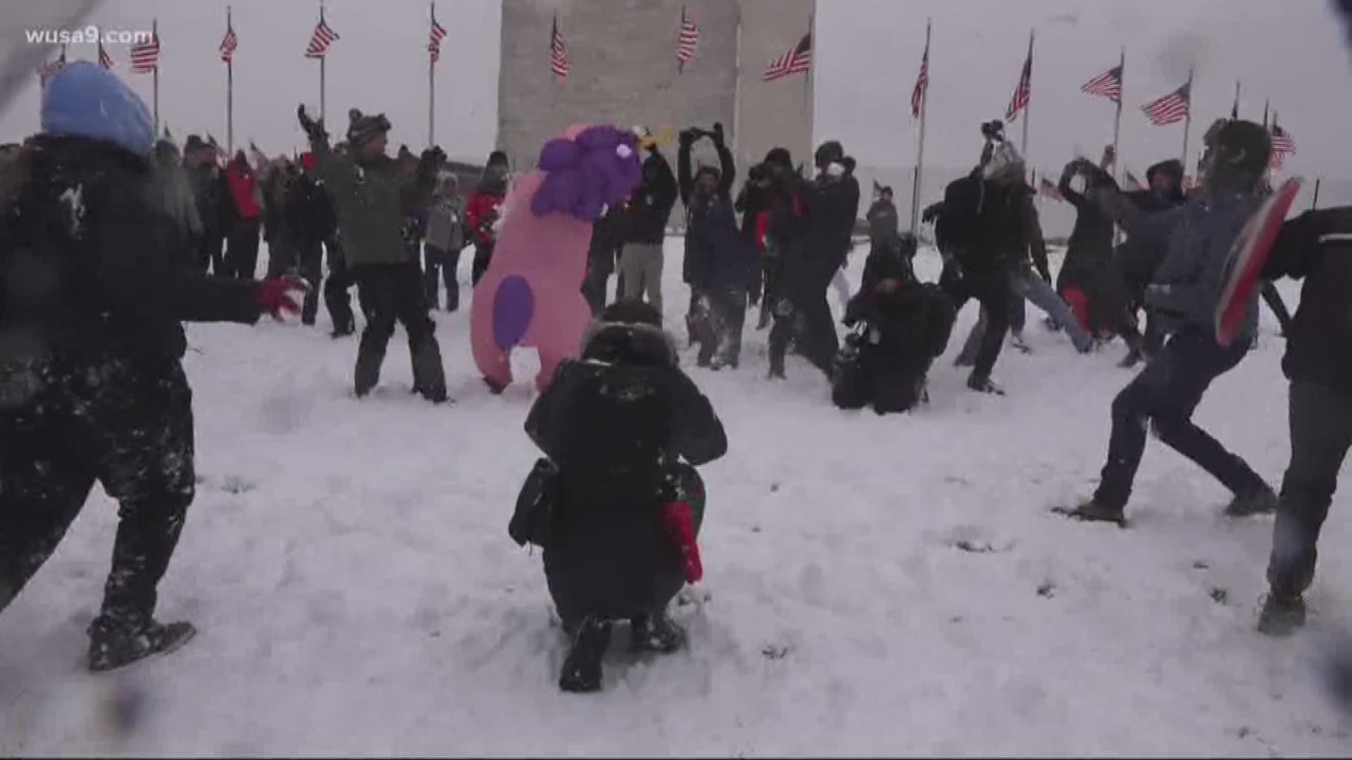
1. January 12 to 14: Winter Storm
After a couple of pitiful winters, this turned into D.C.'s largest snowfall in nearly three years since the blizzard of 2016. Reagan National had accumulating snow for three consecutive days from Jan. 12-14, which was the longest stretch of days with measurable snow in almost four years since February 2015.
The bulls-eye for the event was in the heart of the D.C.-metro and northern Virginia. Reagan National picked up 10.3 inches, which was pretty onpar with some suburbs. Dulles ended with 10.6 inches. Baltimore ran lower with 6.6 inches.
Kids rejoiced -- schools were out, there was a huge snowball fight on the National Mall to celebrate.
2. Late April Storms
April finished incredibly active in 2019 across the DMV. We had three tornado watches for the D.C. area within a two-week period. That's almost unheard of for us.
The pattern turned active on the night of The Masters golf tournament. A line of storms rolled through Sunday evening and night with a few discrete storms ahead of the main batch. We cut into the replay of the Masters on TV due to a tornado warning and significant threat to live and property. In the storm's wake, there was a scattering of wind damage reports in the metro with gusts over 60 mph with trees and wires down. Earlier that day, there were also storms throughout the southeast and they had to move up the start time of the Masters.
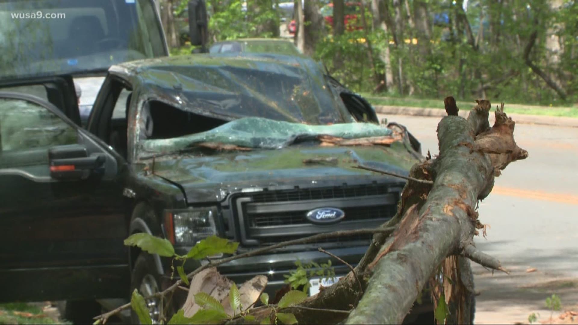
Just five days later, another severe weather event unfolded on a Friday evening with damaging winds and two confirmed tornadoes in the area. An EF-0 tornado with max winds of 70 mph touched down in Reston, Va., leaving a disheveled path on both sides of the Dulles Toll Road, uprooting trees and causing some minor damage to fences and roofs. It was only on the ground for five minutes, but the path left damage across a four mile stretch. The second tornado confirmed that day was an EF-1 in Nelson County, Va.
3. Start of Summer Twisters and Hail
The stormy pattern from April carried into May and June. We had 10 days in May with severe storms in the DMV, and eight days in June. As the calendar changed from May to June, the storms were very intense.
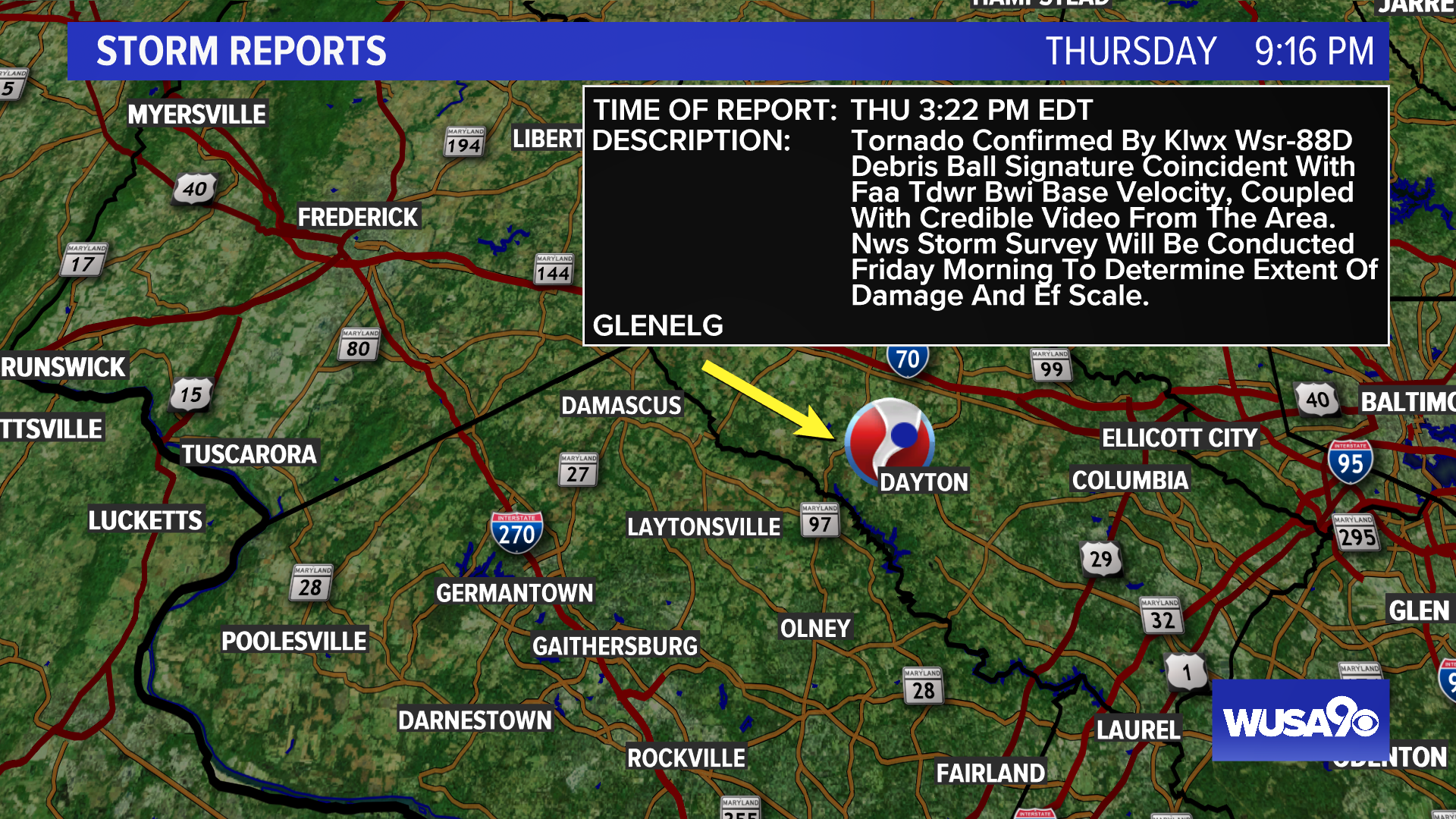
May 30, storms produced damaging winds along the Interstates 66 and 95 corridors in Virginia. Two tornadoes touched down. The first was an EF-0 in Frederick County, Md., which touched town in the southeast suburbs of Frederick and continued east for six miles, uprooting trees along the way. The second tornado was an EF-1 in Glenelg in Howard County, Md.
Just three days later on June 2, another round of storms struck with large hail in D.C., Maryland and Virginia. Hen egg-sized hail fell in Montgomery County, damaging some fences and tree branches. Golf ball sized hail fell in Fairfax County, which is large enough to cause dents in car and shatter windshields. And in D.C., hail was as large as a ping pong ball.


The twisters, damaging winds and hail made for a rough start to summer.
4. July 8th Flash Flood Emergency
It doesn't matter how long you've lived in the D.C. area, you've probably never seen anything as extreme in town as the July 8 flash floods. A slow-moving thunderstorm dropping absolutely torrential rained moved through the heart of the D.C.-metro during the morning commute, turning gridlocked roads into rushing rivers and swimming pools.
In D.C., 3.3 inches of rain fell in under an hour with a storm total of 3.44 inches. Creeks and streams quickly turned into rushing rivers, overflowing onto nearby roadways.
The water levels on Chain Bridge Road rose so quickly that motorists were stranded, forced to get out of their cars and stand on the roofs to avoid the flood waters.
And it was a similar scene in the District on South Capitol Street, along with other low-lying points on area roadways.
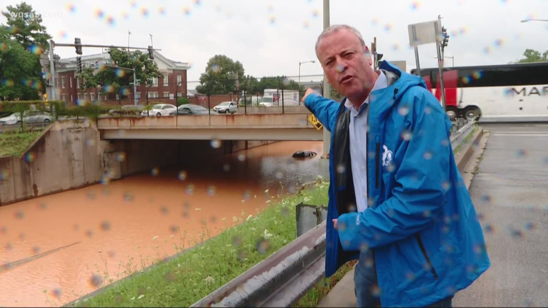
On the northwest side of the beltway in North Potomac, there were several roads that washed out because drainage pipes failed from the shear force of water and debris flowing through them. And in McLean, Va., a little league baseball field turned into a lake in a matter of minutes.
This will go down as one of D.C.'s most notorious flash floods. And for that reason, it's one of our top five most extreme weather events of 2019.
5. Late Summer Flash Drought and Heat
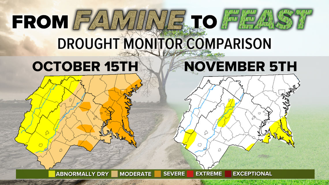
After an exceedingly wet spring and first half of summer, the water hose cut off and D.C. endured a dry three-month stretch from July 15 through Oct. 15 that led to moderate- to severe-drought conditions across much of the DMV (see image below). It was D.C.'s fourth driest September with only 0.25-inch of rainfall. October began with its hottest October temperature on record on Oct. 2 with a high of 98 degrees.
We kept our rain-free streak going through the first two weeks of the month and drought conditions worsened. In the graphic below, you'll see the drought monitor in the middle of October with a severe drought across the D.C.-metro and southern Maryland.

Everything turned dry in a hurry as the flash drought unfolded. The waters of the Potomac River were so low that you could walk across from Virginia to Maryland without a boat.
RELATED: Thanks to a flash drought, you can now cross from Virginia to Maryland without a boat or a bridge
All of a sudden, the water hose turned on and from the Oct. 16 to 31, D.C. picked up 6.52 inches of rain, including four days of at least an inch of rainfall. This quickly eliminated the drought for the start of November.