
WASHINGTON — It will be soggy Wednesday but not a total washout.
Quick Forecast:
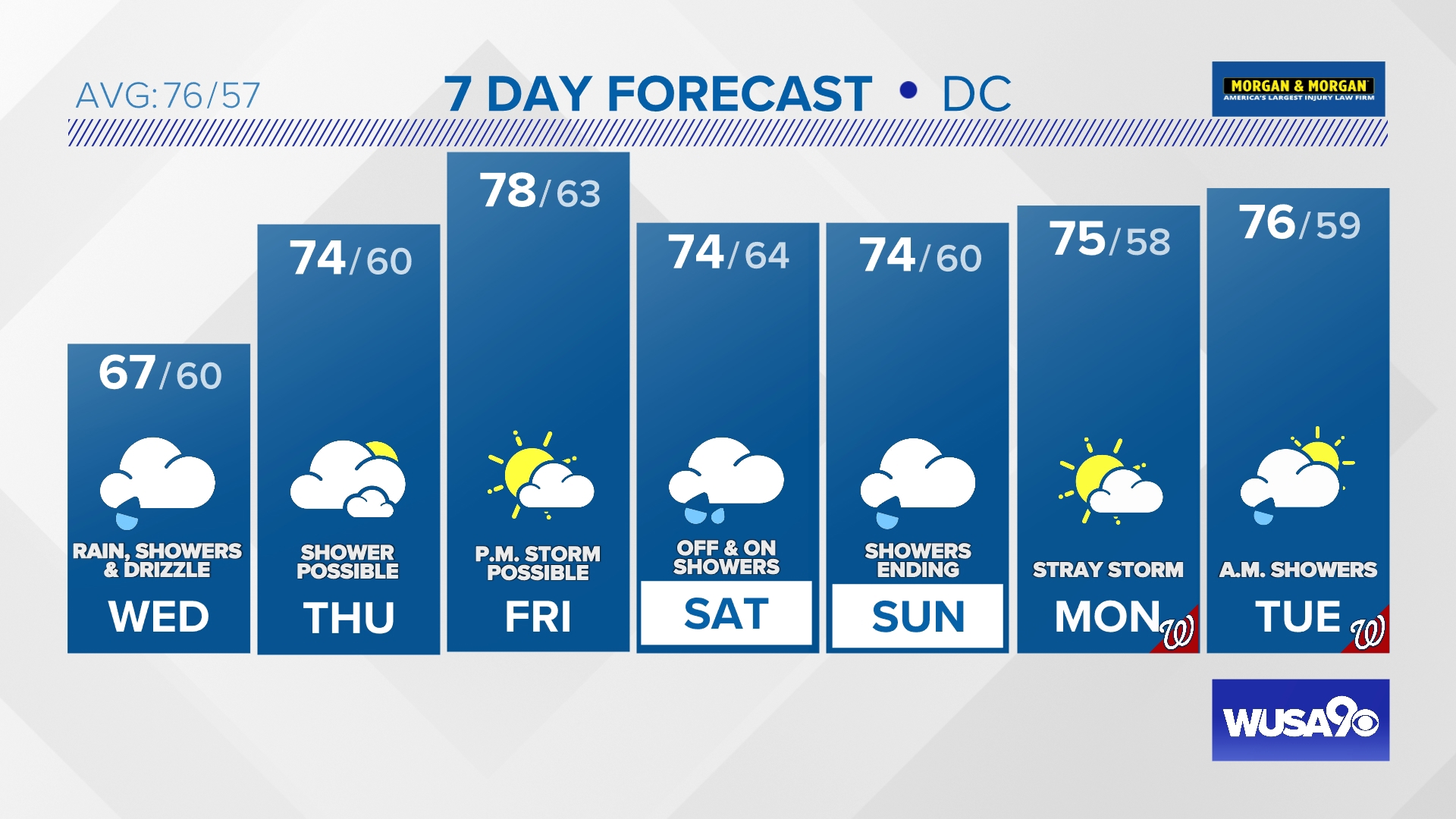
Tonight: Cloudy and damp with more rain and showers. Low: 61.
Wednesday: Rain and showers and drizzle in the afternoon. Cloudy. High: 67.
Wednesday Night: Mostly cloudy and mild. Some showers. Low: 60.
Thursday: Slowly clearing skies. A spotty shower. High: 74.
The wet weather will continue overnight into Wednesday morning. Plan on a slow morning drive with periods of light to moderate rain. Most shower activity clears out by late morning with lingering light showers and areas of drizzle into the afternoon and evening. Clouds will keep temperatures cooler once again in the mid to upper 60s.
We'll be tracking a spotty shower or two overnight into Thursday morning with otherwise cloudy skies. Clouds will be slow to clear Thursday but we should see some breaks of blue by late afternoon with a low chance for an isolated light shower.
Here is the latest pollen report:


Detailed Forecast:
Tonight: Cloudy and damp with more rain and showers. Lows: 56 - 64. Winds: E 10.
Wednesday: Rain and showers and drizzle in the afternoon. Cloudy. Highs: 64 - 69. Winds: NE 10.
Wednesday Night: Mostly cloudy and mild. Some showers. Lows: 54 - 62. Winds: N 10.
Thursday: Slowly clearing skies. A spotty shower. Highs: 72 - 77. Winds: NW 10.
Friday will feature partly cloudy skies and milder temperatures in the upper 70s. We're tracking the potential for a late evening shower or storm but right now rain chances look low.
An area of low pressure will pass through the region over the weekend bringing more showers and periods of rain. Right now Saturday is looking like the wetter of the two weekend days with only a few scattered showers likely Sunday.
Extended Forecast:
Friday: Partly cloudy and milder. Highs: 74 - 79.
Saturday: Clouds and showers. An isolated storm possible. Highs: 71 - 76.
Sunday: Mostly cloudy with a few scattered showers. Highs: 70 - 75.
Monday: A mix of clouds and sunshine with a stray shower or thunderstorm. Highs: 74 - 79.
Tuesday: Morning showers with clearing skies. Highs: 73 - 78.


MORE WAYS TO GET WUSA9
DOWNLOAD THE WUSA9 APP
Apple App Store: WUSA9 News on Apple
Google Play Store: WUSA9 News on Android
HOW TO ADD THE FREE WUSA9+ APP TO YOUR STREAMING DEVICE
ROKU: add the channel from the ROKU store or by searching for WUSA9.
For both Apple TV and Fire TV, search for "WUSA9" to find the free app to add to your account. Another option for Fire TV is to have the app delivered directly to your Fire TV through Amazon.