WASHINGTON — Quick Forecast:
Overnight: A few more snow showers <1", windy and colder. Low: 30.
Wednesday: Returning mostly sunny, still windy and cold. High: 43.
Thursday: Partly cloudy and milder, some late clouds. High: 49
RELATED: Latest area closings/delays
FORECAST DISCUSSION:
Look for more snow showers overnight ending very early Wednesday morning. Plan on a trace to less than an inch. While we will see some early morning clouds Wednesday, sunshine returns with highs in the upper 30s to low 40s. Thursday is the pick of the week with highs around 50 under partly cloudy skies.
Detailed Forecast:
Overnight: Mostly cloudy, windy and cold with more snow showers, <1". Lows: 25 - 31. .Winds: NW 10 - 20 +.
Wednesday: Returning mostly sunny, still windy and cold. Highs: 38 - 43. NW 10 - 20.
Thursday: Partly cloudy and milder, some late clouds. Highs: 45 - 50. Winds: NW/S - 10.
Timing:
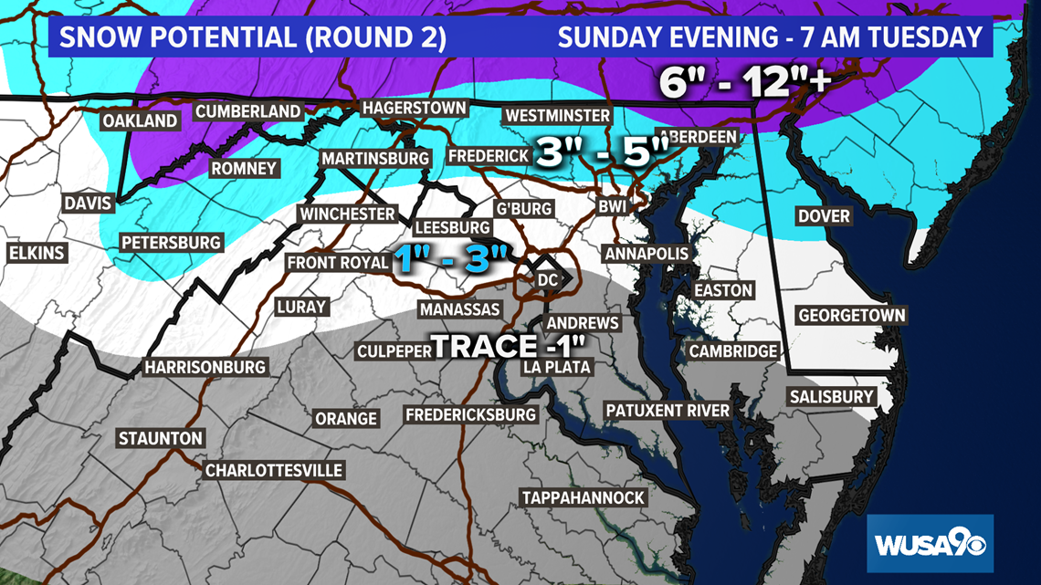
Monday: 10 p.m. - 5 a.m. Tuesday -- Light snow and flurries continue. Some icy spots are possible.
Tuesday: 5 a.m. - 5 p.m. -- Scattered light snow showers, up to another 1/2 inch of snow is forecast.
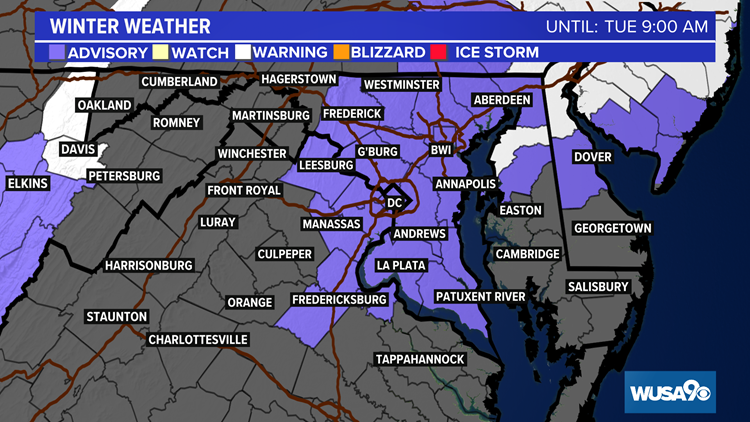
D.C. and most of the DMV is under a Winter Weather Advisory until 9 a.m. Tuesday morning with a Winter Storm Warning north until 9 a.m. Tuesday.

A Few Snow Stats:
On Monday, Jan. 25, 2021, snowfall was finally recorded at Reagan National Airport for the first time this season. It was a paltry 0.3", but that is already 50% of the 2019-2020 winter's total of 0.6".
You have to go back almost two years to Feb. 20, 2019, to see the last 1" snowfall at Reagan National when 2.6" was measured.
The last BIG snowstorm at DCA was Jan. 12 and 13 of 2019 when 10.2" fell with 8.3" of that on the 13.