
WASHINGTON — Plan on a mostly cloudy but also mostly dry Friday forecast.
Quick Forecast:
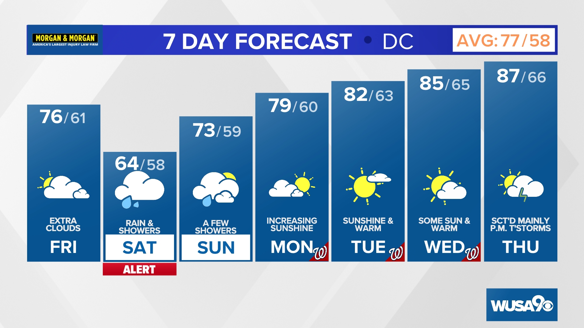
Friday: Mostly cloudy and comfortable with an isolated PM shower. High: 76.
Friday Night: Mostly cloudy and mild with showers, mainly late. Low: 61.
Saturday (Weather Watch Alert): Cloudy and cool with periods of rain and showers, heaviest during the morning. High: 64.
Saturday Night: Cloudy and cool with a few showers. Low. 58.
Plan on a mostly cloudy but mostly dry day with seasonable highs in the mid 70s. Some showers are possible after 3 p.m., but the best chance for wet weather will be well north and west of D.C.
Widespread rain and showers will move in late tonight and by the time you wake up Saturday it will damp and dreary across the region with chilly temperatures throughout the day in the upper 50s and low 60s. The heaviest and steadiest rain will be in the first half of Saturday with a drier, but still damp, afternoon and evening.
Here is the latest pollen report:


Detailed Forecast:
Friday: Becoming cloudy with scattered late-day showers possible, mainly west of the District. Not as warm. Highs: 73 - 78. Winds: NE/SE 5 - 10.
Friday Night: Cloudy with occasional rain developing, especially after midnight. Lows: 56 - 62. Winds: SE 5 - 10.
Saturday (Weather Watch Alert): Cloudy with occasional rain and drizzle. Highs: 61 - 66. Winds: E 5 - 10.
Saturday Night: Cloudy and cool with a few showers. Low. 58. Winds: E - 10.
Sunday is trending drier with only a few light spotty showers and areas of drizzle in the morning. We may even see some sunshine by Sunday afternoon! Temperatures will also be milder in the upper 60s and low 70s.
The sunshine returns just in time for everyone to go back to work and school Monday. Plan on seasonably warm temperatures Monday in the mid 70s before we crank up to the 80s on Tuesday, Wednesday and Thursday.
Next week is also trending much drier with only a few scattered showers and storms possible Thursday.
Extended Forecast:
Sunday: Cloudy with spotty showers, especially during the morning, then some clearing. Highs: 70 - 75.
Monday: Becoming mostly sunny, breezy and warmer. Highs: 76 - 81.
Tuesday: Mostly sunny and warm. Highs: 79 - 84.
Wednesday: Partly sunny and quite warm. Highs: 82 - 87.
Thursday: Mostly cloudy and warm with scattered PM showers and thunderstorms. Highs: 84 - 89.


MORE WAYS TO GET WUSA9
DOWNLOAD THE WUSA9 APP
Apple App Store: WUSA9 News on Apple
Google Play Store: WUSA9 News on Android
HOW TO ADD THE FREE WUSA9+ APP TO YOUR STREAMING DEVICE
ROKU: add the channel from the ROKU store or by searching for WUSA9.
For both Apple TV and Fire TV, search for "WUSA9" to find the free app to add to your account. Another option for Fire TV is to have the app delivered directly to your Fire TV through Amazon.