
WASHINGTON — You hear snow is coming: Most likely your first question is how much in my backyard? Several days out, it's one of the hardest questions for a meteorologist to answer. In fact, sometimes the best information boils down to the last minute.
So why is it so hard to nail down the numbers? When it comes to winter storms like Sunday's when warm air is introduced midway through, it's always a challenge. A slight shift in the track or a few degrees warmer or cooler can have big impacts on snow totals.
The storm heading our way this weekend will move in from the west and then intensify as it moves over the ocean and becomes a Nor'easter. Storms that take this track are referred to as "Miller Type-B," named after the researcher who came up with the classification, J.E. Miller.
If everything lines up with the Miller B type storm, you can get big snow numbers. For example Snowmaggedon of 2010, was a Miller Type-B storm.
Sometimes with these types of storms as the energy is transferring from the parent storm to become the coastal storm, you miss out on some of that energy, and thus, miss out on some snow.
As the storms travel toward the Appalachian Mountains, they can become a bit disrupted before they reform and pick up steam over the ocean and travel along the East Coast.
WUSA 9's Chief Meteorologist Topper Shutt, a more than 30 year veteran forecaster in D.C., has watched the dynamics of storms come together.
"I've been here a long time and that second storm will break your heart," he told viewers during the 6 p.m. WUSA 9 broadcast. "I"m pulling for those numbers [higher snow numbers], believe me," he told viewers.
Sunday is the first wave (the overrunning phase), at which point most areas will get the bulk of thier snow, Shutt said.
On Monday during the second wave areas north and west of DC will still get a second thump of snow, but from D.C. and areas south the chances of getting a lot of additional snow are not as high.
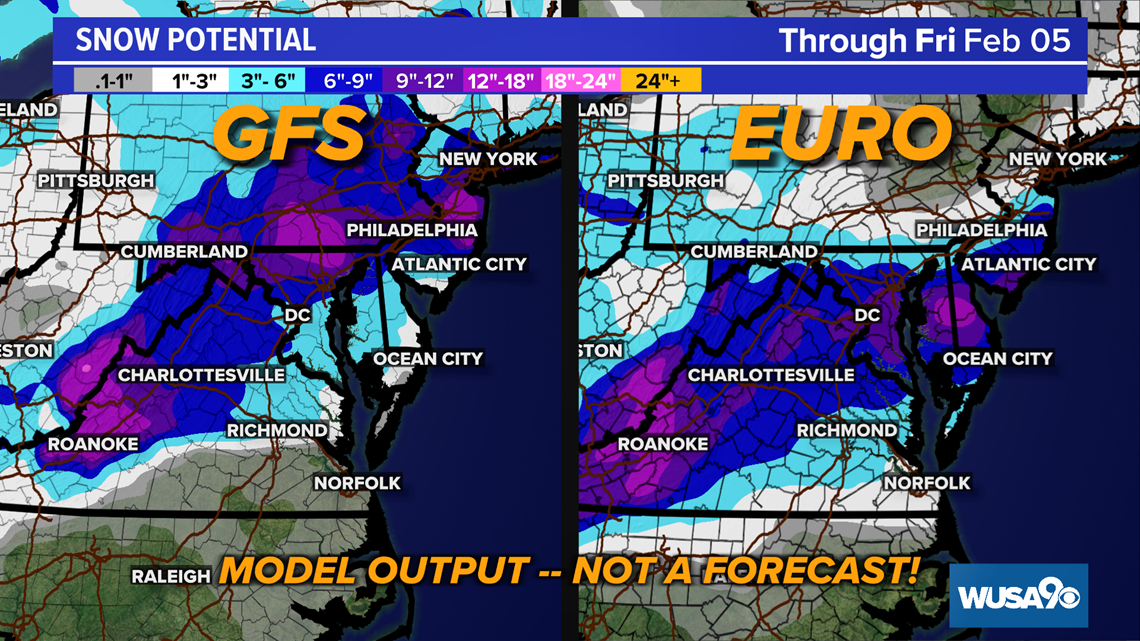
What About The Snow Map
We typically put out snow maps within 2 to 3 days of a snow event. At that point we have more models giving us information from which we can make a more informed decision.
The numbers are likely going to shift, especially as we get closer to the storm and the models begin to handle the data better.
Get Up DC's morning meteorologist Howard Bernstein has been forecasting in D.C. for more than 20 years. Suffice to say he's seen a snow storm or two.
"It's like trying to hit 10 moving targets at the same time. We're trying to figure out, (A) How much moisture there's going to be. (B) If it's going to be snow, what's that ratio going to be? A lot of times you have 10:1, that's a general rule, sometimes it's 5:1, sometimes they're 20:1 if it's cold enough."
A snow ratio of 10:1 means that for every 1 inch of liquid we could get 10 inches of snow. Bernstein said that another challenge is the infamous rain - snow line.
"So how much snow versus sleet vs freezing rain, rain back to snow? That rain-snow line where it's going to set up? And how are those ratios are going to work out? That is very difficult and that's the main challenge that we're facing with this particular storm and one of the things that we face a lot around here," Bernstein said.

"Some of it is an art form of using your gut , first looking at data ,and you want to think about it. You can't be a model reader. You want to think about what's happening in the atmosphere."
The numbers will change - We're not changing the numbers for the fun of it and it's not because we don't know: As we get better data in closer to the storm we simply want to share that with you. As you likely wouldn't want food that's been sitting on the counter for 24 hours, you likely don't want an outdated forecast as well.